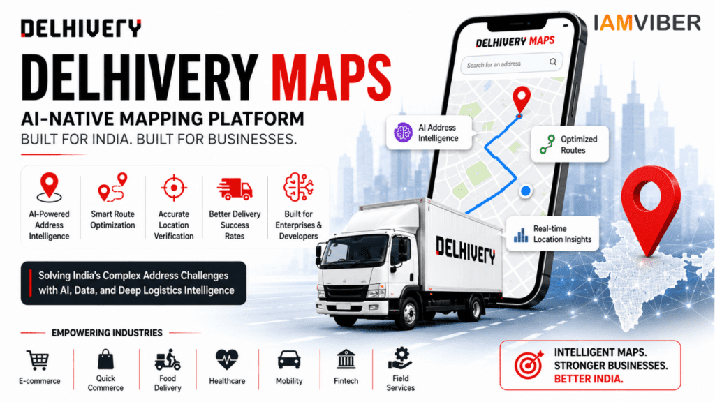
Indian logistics giant Delhivery has announced the launch of Delhivery Maps, a new AI-native mapping platform designed to tackle one of India’s most complex business challenges—address intelligence and route optimization. The launch coincides with the company’s 15th anniversary and marks a significant expansion of technology that was previously used exclusively within Delhivery’s own logistics network.
For years, Delhivery has relied on proprietary mapping and routing systems to power millions of deliveries across the country. With the launch of Delhivery Maps, the company is now opening this infrastructure to external enterprises, developers, e-commerce companies, gig-economy platforms, and businesses that depend heavily on location-based operations.
The move comes at a time when Indian businesses are increasingly seeking technology solutions tailored to local challenges rather than relying solely on global platforms that may not fully understand the complexities of India’s address ecosystem.
Why India's Address System Creates a Unique Challenge
Unlike countries with highly standardized addressing systems, India presents a unique challenge for logistics providers. Addresses are often written using landmarks, local references, neighborhood nicknames, or incomplete information. In many cases, delivery personnel rely on directions such as “near the temple,” “opposite the market,” or “behind the school” rather than precise street addresses.
This creates significant operational hurdles for businesses involved in logistics, food delivery, mobility services, healthcare distribution, and field operations. Failed deliveries, delayed shipments, increased fuel costs, and customer dissatisfaction are often direct consequences of inaccurate address interpretation.
Delhivery says its new platform was specifically developed to address these issues using artificial intelligence and years of real-world logistics data collected across India.
Delhivery Maps Brings Internal Logistics Intelligence to External Businesses
According to the company, Delhivery Maps has been built using technology that has already been tested extensively within its national logistics network. Rather than creating a consumer navigation app, Delhivery is positioning the platform as an enterprise-focused location intelligence solution.
The platform is designed to help businesses identify addresses more accurately, improve route planning, verify locations, and reduce inefficiencies caused by incorrect or incomplete customer information.
Industry observers view the launch as an important step for Delhivery as it evolves from a logistics company into a broader technology and infrastructure provider.
One of the biggest differentiators of Delhivery Maps is its focus on address intelligence rather than simple navigation.
Traditional mapping systems generally work best when users provide complete and accurate addresses. However, Indian addresses frequently contain inconsistencies, abbreviations, local terminology, and landmark-based instructions. Delhivery Maps uses AI models trained on years of logistics operations to better understand these patterns.
By analyzing address behavior, delivery histories, geographic context, and location signals, the platform aims to identify precise destinations even when the original address data is incomplete.
For businesses handling thousands of deliveries daily, even small improvements in address accuracy can translate into major operational savings.
Route Optimization Could Reduce Delivery Costs
Beyond address intelligence, Delhivery Maps also focuses on route optimization. Efficient routing remains one of the most important factors in logistics performance, especially as delivery volumes continue to rise across India.
The platform reportedly takes into account factors such as road accessibility, vehicle suitability, local road conditions, and delivery constraints to generate more effective routes.
For logistics operators, this could lead to faster deliveries, lower fuel consumption, better fleet utilization, and improved delivery success rates.
As competition intensifies across e-commerce and quick-commerce sectors, businesses are increasingly looking for technologies that can improve operational efficiency without significantly increasing costs.
Applications Extend Beyond Logistics
Although Delhivery Maps originates from the logistics sector, its potential applications extend far beyond parcel delivery.
E-commerce companies can use the platform to improve delivery accuracy and customer experience. Food delivery services may benefit from faster location identification and reduced delivery delays. Ride-hailing platforms can potentially improve pickup efficiency and route planning.
Healthcare organizations, financial institutions, hyperlocal service providers, and gig-economy platforms are also likely to find value in enhanced address verification and location intelligence capabilities.
As businesses become more dependent on real-time location data, the demand for specialized mapping infrastructure is expected to increase significantly.
A Growing Trend in India's AI Infrastructure Ecosystem
The launch of Delhivery Maps reflects a broader trend emerging across India’s technology landscape. Instead of focusing solely on consumer-facing AI products, companies are increasingly developing AI infrastructure designed to solve large-scale operational challenges.
From logistics and supply chains to fintech and healthcare, Indian businesses are beginning to build solutions that address uniquely local problems using artificial intelligence and domain-specific data.
In many ways, Delhivery Maps represents this new wave of AI innovation—technology built not just to automate tasks, but to solve real-world inefficiencies that affect millions of transactions every day.
Can Delhivery Maps Compete with Established Mapping Platforms?
The launch naturally raises questions about competition within the mapping industry. However, Delhivery Maps appears to be targeting a different market segment than traditional consumer navigation platforms.
Rather than helping users find restaurants or navigate daily commutes, the platform focuses on enterprise use cases where address intelligence, delivery success rates, and operational efficiency are critical business metrics.
This specialization could allow Delhivery to carve out a strong position in enterprise logistics and location intelligence, particularly among businesses operating in India’s complex delivery environment.
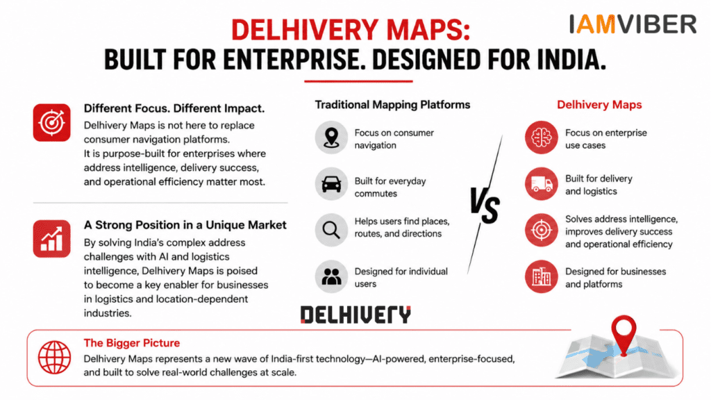
The Bigger Picture
The introduction of Delhivery Maps highlights how logistics companies are increasingly transforming into technology companies. What began as an internal operational tool has now evolved into a commercial platform that could serve a wide range of industries.
As India’s digital economy continues to expand, businesses will require more accurate location intelligence, smarter routing systems, and AI-powered infrastructure capable of handling the country’s unique geographic and address-related challenges.
With Delhivery Maps, Delhivery is betting that the future of logistics and location-based services will be powered not just by maps, but by intelligent systems that understand how India actually works.
For businesses struggling with address accuracy, routing inefficiencies, and last-mile delivery challenges, Delhivery Maps could become one of the most interesting infrastructure launches to watch in 2026.
Frequently Asked Questions (FAQs)
What is Delhivery Maps?
Delhivery Maps is an AI-native mapping and location intelligence platform launched by Delhivery. It is designed to improve address accuracy, route optimization, and location verification for businesses operating in India.
Why did Delhivery launch Delhivery Maps?
Delhivery launched Delhivery Maps to address India’s complex addressing system and help businesses reduce delivery failures, improve routing efficiency, and enhance operational performance through AI-powered address intelligence.
Who can use Delhivery Maps?
Delhivery Maps is built for enterprises, developers, e-commerce companies, logistics providers, gig-economy platforms, healthcare organizations, and other businesses that rely on accurate location data and routing.
How is Delhivery Maps different from traditional mapping platforms?
Unlike traditional mapping platforms that focus on consumer navigation, Delhivery Maps is designed for enterprise use cases. It emphasizes address intelligence, route optimization, location verification, and logistics efficiency rather than general navigation.
Does Delhivery Maps use artificial intelligence?
Yes. Delhivery Maps uses artificial intelligence to interpret incomplete addresses, improve geocoding accuracy, optimize delivery routes, and enhance location verification for businesses operating across India.
Can Delhivery Maps improve last-mile delivery?
Yes. By providing accurate address identification and optimized routing, Delhivery Maps can help businesses reduce delivery delays, lower operational costs, and improve last-mile delivery performance.
Topics to follow: Current Affairs & Insights Tech Innovation GenZ entrepreneurship Collaborative Fashion GEO AI Agentic SME